North Slope Search and Rescue helicopter dropping off George Divoky with all his gear for the 2018 field season. Image Credit: Leslie Pierce
This short one-minute video shows the approach to Cooper Island from a North Slope Search and Rescue Helicopter loaded with 800 pounds of gear and our intrepid field scientist, George Divoky. Video Credit: Leslie Pierce
This clip is part of an ongoing series titled Arctic Change centered around George Divoky’s 44th field season studying Black Guillemots, sea ice, and climate change on a remote Arctic island off the coast of Alaska. To donate and support Divoky’s work on Cooper Island, visit the Friends of Cooper Island.
An aerial view of Cooper Island from 2014. Image Credit: George Divoky
An aerial view of Cooper Island from 2014. Image Credit: George Divoky
Great to be back on Cooper island after two intense weeks of preparation in Seattle and Utqiaġvik. Arriving on the island begins an even more intense period as I need to turn the 8-by-12 foot cabin from the overwinter storage shed it has been for the past nine months into a place where I can sleep, cook, process data–and eventually even relax.
A low-level aerial shot of camp from just east, circa 2012. Image Credit: George Divoky
Concurrently, I have been setting up my power sources (solar and wind generators powering a battery bank) and communications (satellite phone, inReach and VHF radio) that keep the camp running and connected to the outside world. While the large snowdrift that currently surrounds my cabin impedes my accomplishing these tasks, it does provide my drinking water for the first half of the summer. Throughout the day I have been shoveling snow into any available container as the island has no fresh water and I need to melt as much snow as possible before it disappears.
All of the required logistics chores need to be balanced with the daily fieldwork. Since my arrival three days ago, conditions for censusing the colony and retrieving geolocators have been excellent with clear skies and little wind. While visiting all nest sites to determine who survived the winter and who is breeding with whom is the highest priority, I also need to retrieve the geolocators that I put on 25 birds at the end of the 2017 breeding season. Catching the birds in their nest cases has gone well this year with nine of the units retrieved in the past two days.
These light-sensitive data loggers record the time of sunrise and sunset each day allows me to determine their location for the nine months they have been away from the colony. We have deployed geolocators since 2011 and this year’s data is extremely important since the Bering Sea ice, where guillemots typically winter, did not form this past year. The effect of this unprecedented event on guillemot movements and distribution will be one of this summer’s most important findings.
Black Guillemots in 2012. Image Credit: George Divoky
I will know the size of this year’s breeding population in about a week and, since many of the females have had low colony attendance in the last few days and are likely offshore building up reserves for egg laying, the first clutches should be appearing within the next 4-5 days.
Looking forward to sharing what is promising to be a most interesting and important field season.
This field is part of an ongoing series titled Arctic Change centered around George Divoky’s 44th field season studying Black Guillemots, sea ice, and climate change on a remote Arctic island off the coast of Alaska. To donate and support Divoky’s work on Cooper Island, visit the Friends of Cooper Island.
George Divoky's 2018 arrival on Cooper Island for his 44th field season. Image Credit: Craig George
George Divoky’s 2018 arrival on Cooper Island for his 44th field season. Image Credit: Craig George
June 19, 2018, after several weather-related delays, Search and Rescue pilots transported George and his gear to Cooper Island. His cabin is packed floor to ceiling with supplies stored over the winter, and he arrived with 800 pounds of equipment to support his 44th season studying Arctic seabirds.
While the Arctic has experienced back-to-back record-breaking years of warming, Utqiaġvik and North Slope of Alaska encountered unusually cold weather and snowfall this spring. According to George, he hasn’t seen conditions like this since the 1970s.
The most recent image of NOAA’s Earth System Research Laboratory (ESRL) Barrow Observatory show snow accumulation in the middle of June 2018. Image Credit: NOAA ESRL
He predicts the late snowmelt will make this season particularly difficult for his Black Guillemots, who are already struggling to adapt to an ecosystem imperiled by climate change.
The delayed breeding season means the parents will have to fly farther to reach retreating sea ice in order find food that is ideal for guillemot chicks.
The longer distance means the parents expend more energy, which is a precious commodity for seabirds. In Far from Land, Michael Brooke writes, “Natural selection will favour individuals which do not imperil their own long-term chances of survival by recklessly over-investing in any single year’s offspring.” Brooke adds that it is better to forgo a single year’s offspring in the hopes of future generations of potential chicks, because seabirds like albatross and guillemots tend to lay small clutches of eggs. The Cooper Island birds typically lay two eggs each year.
Based on previous year’s data collected via geolocators George uses to track the birds, he thinks they’ve been in Nuvuk for the last month. Also known as Point Barrow, this headland is about nine miles east of Utqiaġvik. The guillemots are waiting for the snow to melt, George says.
“Snowmelt at NOAA’s Barrow Observatory typically occurs about a week before egg laying,” George noted on social media. “Female guillemots don’t ovulate until snowmelt allows access to the nest cavity.”
George waves goodbye from Cooper Island on June 19. Image Credit: Craig George
Once George sets up camp — which is no small feat alone in freezing temperatures — he’ll be sending us regular updates via satellite, which we will be sharing here. Follow us on Facebook, Twitter, and Instagram for the latest news and Arctic insights.
This story is part of an ongoing series titled Arctic Change centered around George Divoky’s 44th field season studying Black Guillemots, sea ice, and climate change on a remote Arctic island off the coast of Alaska. To donate and support Divoky’s work on Cooper Island, visit the Friends of Cooper Island.
Experts believe climate change is a science communication emergency. Mounting evidence suggests that action now may be our only hope. Image Credit: Jenny Woodman
A traditional view of science literacy focuses on information and facts — on textbook knowledge, but critical science literacy emphasizes awareness of how science is practiced, from the collaborative nature of research and how science is funded to the ways we evaluate what we know to be true at any given moment.
A science literate public is less concerned with scientific concepts rotely-memorized; rather, they are armed with enough understanding to think critically about the world around them and to participate in a democratic society. They are skeptical of sensational science headlines and carefully consider the sources of the information they consume. And, most importantly, they possess agency and autonomy, which strengthens our commitment to provide tools for decision-making without manipulation or covert persuasion.
Informed citizens make better decisions.
However, an ever-changing media landscape creates significant barriers between the public and the scientific understanding necessary to inspire meaningful action on climate change.
While climate change makes headlines daily, there are fewer (and fewer) journalists assigned to science and environmental beats. This combined with the deluge of data and information widely available on the internet makes critical science literacy fundamental in an age where science and technology pervade almost all aspects of our lives.
Evidence of sea level rise, hypoxic zones, and ocean acidification are just a few of the indicators that suggest the ocean is inextricably linked with climate change. Factoring in other human-caused stressors like plastic and pollution adds an even greater sense of urgency to the task of communicating about how oceanic changes impact our future and the future of many other species.
Experts believe climate change is a science communication emergency. Mounting evidence suggests that action now may be our only hope.
The ocean poses additional challenges for engagement. Over 70 percent of Earth’s surface is covered by water, but most of the ocean is out of sight and out of mind for the students, activists, and change-makers who might help mitigate threats to our vital ocean ecosystems.
Because of this disconnect between awareness and the scope of threats to our oceans, vast expanses of our planet remain unexplored and unknown. In the deep, cold waters, there are mountains that would tower over the Himalayas and bioluminescent sea creatures who use tools. There are species that coordinate with other species to hunt and survive in the harshest of environments. Currently, at least half of the anticancer drugs on the market come from marine resources, so ancient sea sponges and cold-water corals we’re discovering now may unlock medical breakthroughs the likes of which we can only imagine.
How do you build literacy and engage with something so distant, with a place that seems out of our reach? We’re working to build emotional investment in ocean issues with multimedia storytelling and informal science education.
Science is a human endeavor and we are storytellers constantly searching for the connective tissue to make an audience keep reading, keep looking, and — most importantly — keep thinking.
Jenny Woodman, Proteus founder and executive director, is a science writer and educator living in the Pacific Northwest; she is a 2018 lead science communication fellow for the Exploration Vessel Nautilus. Follow her on Twitter @JennyWoodman.
Life on a blue planet. Image Credit: Jenny Woodman
USNS Comfort, a 1000 bed hospital ship, on the way to provide disaster relief in the aftermath of Hurricane Katrina, 2005. Image Credit: Henry J. Holcomb
Left to right: Borman, Holcomb, Anders, and Lovell on the deck of the USS Yorktown. Image Credit: AP Photo/Bob Schultz.
Woodman leaving San Francisco Bay on the E/V Nautilus in 2017. Image Credit: Jenny Woodman
The Exploration Vessel (E/V) Nautilus is a 211 foot former East German “fishing boat” fully outfitted for scientific exploration. Image Credit: OET/Nautilus Live
As a kid, I sprawled out on the shag carpet in our family room reading Nancy Drew mysteries and watching Star Trek. My childish imaginings were punctuated by the steady rhythmic sound of an electric typewriter clicking and humming in the nearby study where my dad wrote at home. He is a newspaper man. Over the span of his 45 year career he covered everything from the local school board meetings to state capitals, from the Apollo 8 splashdown to the revitalization of the Naval shipyards in Philadelphia.
I spent my childhood loitering in bustling and grungy news rooms, coloring in the weekday comic strips and waiting for dad to finish this or that important thing. By the late 80s, he was on the foreign desk at the Philadelphia Inquirer where I “helped” edit a story about a young Mikhail Gorbachev leaping up a flight of stairs two at time — the blinking cursor of the Atex computer screen is forever burned in my memory.
Watching him finagle time in the locomotive car of freight trains, on Chinook and Black Hawk helicopters, on US Navy aircraft carriers and on a thousand-bed hospital ship taught meaningful lessons about writing, although I didn’t realize it at the time.
Storytelling takes shape when you get out there: see the drama of boring everyday life unfold in front of you; smell the smoke and diesel fuel; get dirty.
I suppose it’s not surprising that I’ve spent the last few years cornering NOAA administrators and scientists at conventions and meetings, handing out my business card and asking for passage on any ship that would take me. I researched and applied for fellowships and writing residencies.
Finally, my efforts paid off. In 2017, I joined Oceanographer Robert Ballard’s Corps of Exploration on Board the Exploration Vessel (E/V) Nautilus as a science communication fellow. We spent two weeks exploring deep underwater canyons and the edge of the continental shelf in Cordell Bank National Marine Sanctuary with the Nautilus’s beloved robotic duo, Argus and Hercules.
The sanctuary lies off the coast of California, northwest of San Francisco. The sanctuary territory was expanded in 2015 to 1286 square miles of largely unknown deep sea habitats. During over 90 hours of diving with the robots, we found deep sea sponge and coral communities, along with a host of life — octopuses, skates, and catsharks — clinging to and lingering about the rocky substrate at the bottom of the ocean. It was a breathtaking spectacle to witness scientists and sanctuary managers discover new species and gain a deeper understanding of this precious natural area. Their excitement was joyful and contagious.
This summer, I’m heading back to out to sea. Through the Proteus platform, we’ll experiment with a combination of essays, live field reports, graphics, photos, and whatever we can get our hands on to help transport you, our readers, to remote and wonderful places in our own ocean world.
In July, I’ll return to California on the NOAA Ship Bell M. Shimada for a seabird and marine mammal survey. The cruise is part of a collaboration between three National Marine Sanctuaries (Cordell Bank, Greater Farallones, and Monterey Bay) and Point Blue Conservation Science via the Applied California Current Ecosystem Studies (ACCESS) cruises. It will be the 15th year of data collection and observation, helping provide a baseline for understanding sanctuary waters and the impacts of humans and climate change on these regions.
In September, I rejoin the team on board the E/V Nautilus as a lead science communication fellow. This expedition is a joint mission with NASA to explore underwater volcanoes with robots at the Lōihi Seamount. By watching how ocean explorers work remotely from the safety of their vessels in dangerous and unfamiliar environments, NASA can be better prepared for future space missions.
We’ll also be covering George Divoky’s 44th field season in the Arctic where he studies a small colony of Black Guillemots. These seabirds spend most of the year out on the ice; they come to Cooper Island every summer to breed. While George set out to study guillemots in 1975, he also ended up conducting one of the longest running studies of sea ice and climate change along the way. This Plumb Line special series is titled Arctic Change.
With this, our first season at sea and all our future projects we’ll work together to build critical science literacy and to engage the public with the ocean–our planet’s life support system.
George Divoky's Arctic summer home on Cooper Island seen in mid-May 2018. Image Credit: George Divoky
Polar bears are regular vistors.
George at work.
Cooper Island cabin photographed by Search and Rescue pilots in Mid-May 2018. Image Credits: George Divoky
In the early days of his field research, George Divoky slept in a tent, but retreating Arctic sea ice made Cooper Island more accessible to polar bears. In 2003, George installed a cabin and added an electric fence for protection. Snow seen in the photo above will provide additional drinking water during the season.
Cooper Island is 25 miles east of Utqiaġvik, formerly known as Barrow, in Alaska. In Iñupiaq — one of at least 20 Indigenous languages in Alaska and Canada — Utqiaġvik means a place to gather wild roots. It is the northernmost city in North America.
Cooper is a gravel and sand barrier island, only four miles long; it serves as a breeding ground for a small colony of Black Guillemots, which George has studied since 1975.
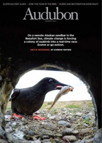
December cover of Audubon Magazine. Image Credit: Peter Mather for Audubon
The Black Guillemots arrive in early June and eggs should be laid several weeks later. George speaks of the birds with an affection most people reserve for other humans.
When the December issue of Audubon Magazine hit the stands with an eye-catching image of one of his feathered friends, he was genuinely excited, pointing out that she had fledged in 1996 and been nesting there since 1999. Of her descendants, several have returned to the island as well. She has 24 grandchildren.
George is eager to see who will return this year, and worried for the ones who might not.
This story is part of an ongoing series titled Arctic Change centered around George Divoky’s 44th field season studying Black Guillemots, sea ice, and climate change on a remote Arctic island off the coast of Alaska. To donate and support Divoky’s work on Cooper Island, visit the Friends of Cooper Island.
This Aqua satellite was launched in 2004; it collects about 89 Gigabytes of data per day about elements of the Earth’s water cycle -- including water in liquid, solid, and vapor form. Image Credit: NASA’s Earth Observing System
This Aqua satellite was launched in 2004; it collects about 89 Gigabytes of data per day about elements of the Earth’s water cycle — including water in liquid, solid, and vapor form. Image Credit: NASA’s Earth Observing System
In the Arctic, much depends on ice. Pack ice. Drift ice. Old ice. New ice. For some wildlife, ice provides safe haven from predators and for others, it offers access to prey. For humans, many of whom are living in isolated coastal communities with no roads in or out, ice is everything.
Sailors and explorers have kept sporadic records about ice conditions dating back thousands of years, but only since 1979, with the launch of Earth observing satellites, have streams of near-constant information about Arctic sea ice been available. Using images and observations captured daily, scientists are able to measure ice thickness, area of coverage, and seasonal fluctuations in the advance and retreat of ice coverage.
Real-time sea ice images and data are vital for the safety of researchers like George Divoky and for people in Arctic communities who depend on ice for subsistence hunting and fishing. Anthony Fischbach is a wildlife biologist for the United States Geological Survey (USGS) in the Alaska Science Center Walrus Research Program, where he has worked since 1994. Fishbach delivers a daily “Ice Mail” to just over 100 people interested in up-to-date information on Arctic sea ice. Subscribers include Divoky, scientists in Russia, and remote Inuit communities who may not have easy access to internet connections capable of retrieving large amounts of data.
“The main niche I’m trying to fill is a way to get meaningful sea ice imagery and charts in the palm of your hand or on the deck of a ship where you’ve got really minimal bandwidth,” said Fischbach. “If you’re in a remote community that has 2G cell phone connection or if you’re on an Iridium-linked vessel, the existing ways of accessing the data just don’t meet the need.”
He described his own experiences of working in Arctic coastal communities or being on board a retrofitted crabber, “We just struggled to get the data through the existing methods and we couldn’t get all the data we wanted.”
Today, Fischbach relies heavily on two satellites we’ll be following closely this summer — Aqua and Terra. Both are part of NASA’s Afternoon Constellation or A-Train, which is a convoy of satellites operated by NASA and international partners. The satellites travel together, completing a polar orbit twice a day; because of the Earth’s rotation, a polar orbit means that the satellites will observe the entirety of the planet’s surface every one to two days.
The A-Train crosses the equator at about 1:30 a.m and 1:30 p.m.; the Terra satellite passes the equator in the early morning, Aqua in the afternoon. This timing and repetition allows scientists to generate cloud-free images and to study how temperatures over land and water change from day to day.
By flying satellites loaded with a host of Earth-observing instruments in a formation, scientists are able to gather a great deal of meaningful data. According to NASA, flying in concert “allows for synergy between the missions—synergy means that more information about the condition of the Earth is obtained from the combined observations than would be possible from the sum of the observations taken independently.”
While each satellite is tasked with different mission objectives, the data from individual instruments can be combined to paint a more vivid and informative picture of the Earth’s climate and atmospheric systems.
This visualization shows the orbits of NASA-related near-Earth science missions that are considered operational as of March 2017. Video Credit: Greg Shirah for NASA Visualization Studio
A key instrument on board Aqua and Terra is a moderate resolution imaging spectroradiometer, or MODIS for short, which is capable of of observing across 36 spectral bands or wavelengths at different resolutions (250, 500, and 1000 meters). (A complete technical profile of this instrument and the data it provides can be found here.)
MODIS is an integral instrument for studying the ocean, because it aids in the creation of ocean color maps. Ocean color reveals much about phytoplankton productivity, which, according to NASA, forms the basis of the ocean’s food chain and plays a big part in carbon storage and movement. MODIS also allows for detailed maps of sea surface temperatures, which are known to influence weather patterns. Since MODIS is able to study water in liquid, solid or gas form, the instrument aids measurement of snow and sea ice and how much solar energy is being absorbed or reflected back to space.
This ice map for May 24, 2018, generated by United States Geological Survey (USGS) in Alaska, combines MODIS images from Aqua and Terra with National Ice Center data. Image Credit: Anthony Fischbach for USGS
Fischbach explains that the images in his daily emails (seen above) are processed with false color so you can distinguish the white of the clouds with the white of the sea ice; sea ice is aqua-colored and the clouds appear white. The images show detail down to 250 meter resolution, meaning you can clearly see objects that are 250 meters or 820 feet wide.
To people living and working in the the Arctic, these sea ice data could be comparable to monitoring hazards on roadways in the lower 48, because the ice and water provide access for both transportation and food.
The ice is moving constantly, which creates precarious decision-making choices in remote regions without the right information. With several days of ice data in hand, people in the field like Fishbach and Divoky can make better choices.
“I’d really like to know as much as I can about how the ice is moving. Is there more ice coming this way? Is it going to be congesting? Is it going to be opening up?” he asks. “You know, do I launch boat out in to the ice — the shifting seascape — where I could get pinned in and trapped and not make it home?”
This story is part of an ongoing series titled Arctic Change centered around George Divoky’s 44th field season studying Black Guillemots, sea ice, and climate change on a remote Arctic island off the coast of Alaska. To donate and support Divoky’s work on Cooper Island, visit the Friends of Cooper Island.


You must be logged in to post a comment.